Maricopa
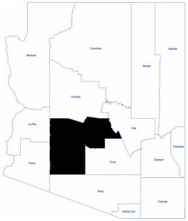
Maricopa County is located near the central part of Arizona and includes Phoenix, Arizona's largest city and the state’s capital. As of 2020, its population was an estimated 4,420,568. It is by far Arizona's most populated county, encompassing more than half of the state's residents.
There are five Indian reservations located in the county. The largest of these are the Salt River Pima-Maricopa Indian Community (east of Scottsdale) and the Gila River Indian Community (south of Phoenix). The county was named in honor of the Maricopa Indians, who were known to have inhabited the area as early as 1775.
Maricopa County is also one of the largest counties in the United States by area having a land area greater than that of seven states.
It occupies desert land along the Salt River in the south-central part of the state, in what Arizonans call the Valley of the Sun. The valley is also the site of such cities as Scottsdale, Tempe, Mesa, Chandler, and Glendale. Together, with Phoenix, they form one of the most rapidly growing metropolitan areas in the nation. Scattered, low mountain ranges surround the valley. On the outskirts of Phoenix are large fields of irrigated cropland and several Indian reservations.
The climate is dry and sunny and marked by mild winters and extremely hot summers. Low humidity prevails throughout the year.
Total Area: 9,224.27 square miles
Land Area: 9,203.14 square miles
Water Area: 21.13 square miles
Cities in Maricopa County
Anthem Avondale Buckeye Chandler Gila Bend Gilbert Glendale Goodyear Litchfield Park Mesa Paradise Valley Peoria Phoenix Queen Creek Scottsdale Surprise Tempe